
Looking for a hike filled with history and beauty? The Adlerbogen hike near Kaiserslautern is filled with Celtic, German and WWII history.
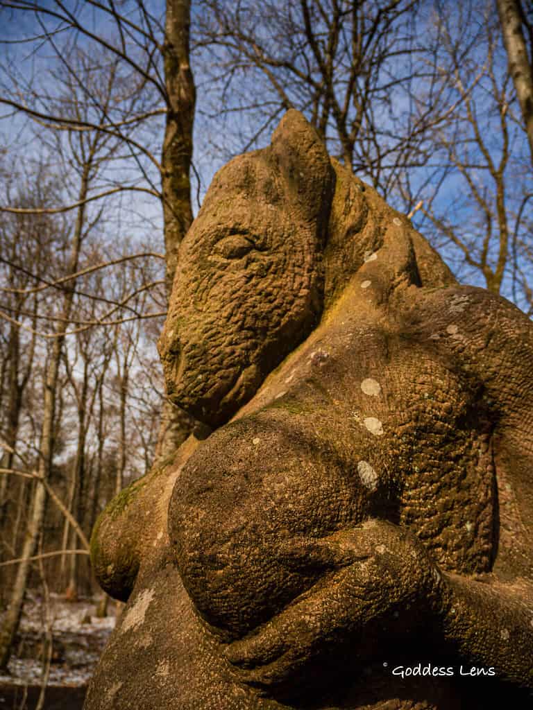
Only 20 minutes from Kaiserslautern, Germany is the Adlerbogen hike. What a hidden gem! Beyond the amazingly well-endowed Celtic horse fertility goddess, there are plenty of reasons to plan this hike:
- The Adlerbogen : Historical Eagle Arch
- Celtic Ring Wall (Reconstructed)
- Celtic Skulpture Trail (Outdoor Installation Art Exhibit)
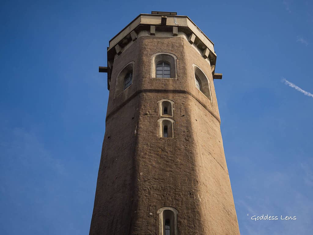
- Ludwigsturm (Historical Tower)
- Keltenhütte (Food and Drinks)
- Options to Make it Easy or Challenging
- Free Parking
Overview Adlerbogen Hike by Kaiserslautern
Location: Dannenfels, Germany
Distance: 2.5, 6.4, or 14.4 miles
Easy hike: 1 hour with 463 ft of elevation
Gear: Nothing special, not stroller friendly
Best Place to Stay: Bastenhaus Spa Hotel
I love travelling to the Alps for a Nature break with relaxing boutique hotels, but it’s pretty amazing that Dannenfels offers a Nature spa and sauna hotel with it’s own wooden swing right in our backyard!
Keep reading to learn how to turn this history and art hike into the perfect spa weekend.
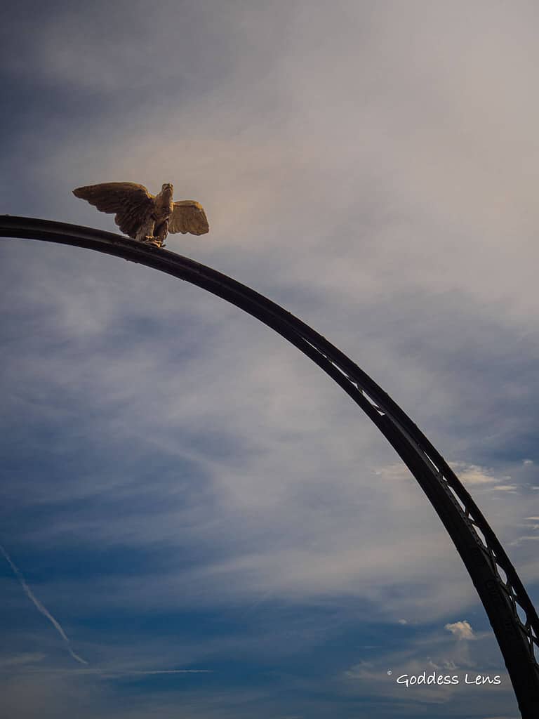
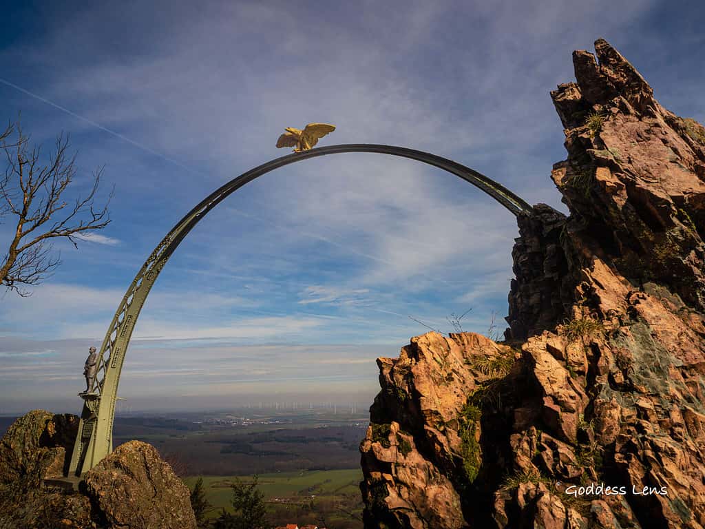
Eagle in German – Adlerbogen is the Eagle Arch
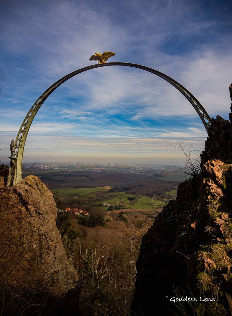
Adlerbogen, also known as the Eagle Arch, is a triumphal arch located on the eastern side of the Donnersberg, a mountain in Germany’s Rhineland-Palatinate region.
Related Hikes Near Kaiserslautern:
- Calmont Klettersteig Hike – A Mini-Adventure Through Europe’s Steepest Vineyard
- Landstuhl Castle Hikes – And Learn about the Bloody Baron of Landstuhl
- Urzig Mosel River Wine Tasting Guide – They are all related? + Ladder Hike
- Geierlay Bridge Guide + How to Park and Hike
- Kirkel Germany Hike – Best for Kids
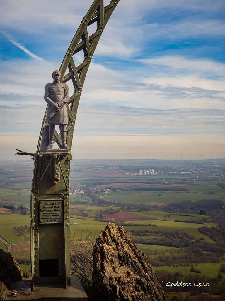
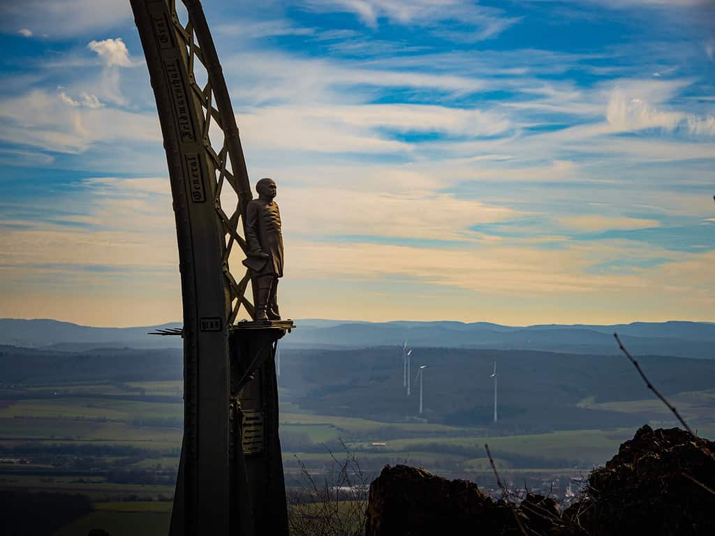
The steel structure was originally built in 1880 to honor Field Marshal Count Helmuth von Moltke and Chancellor Otto von Bismarck. The arch spans 12.50 meters and is stretched about 30 meters above the valley floor between two rocky peaks of the Moltkefelsen.
The arch is an important monument of the German Empire and an early symbol of tourist development of the Donnersberg region.
Adlerbogen Spa – Hiking – Biking Weekend
Indulge in a spa weekend at the foot of Adlerbogen.
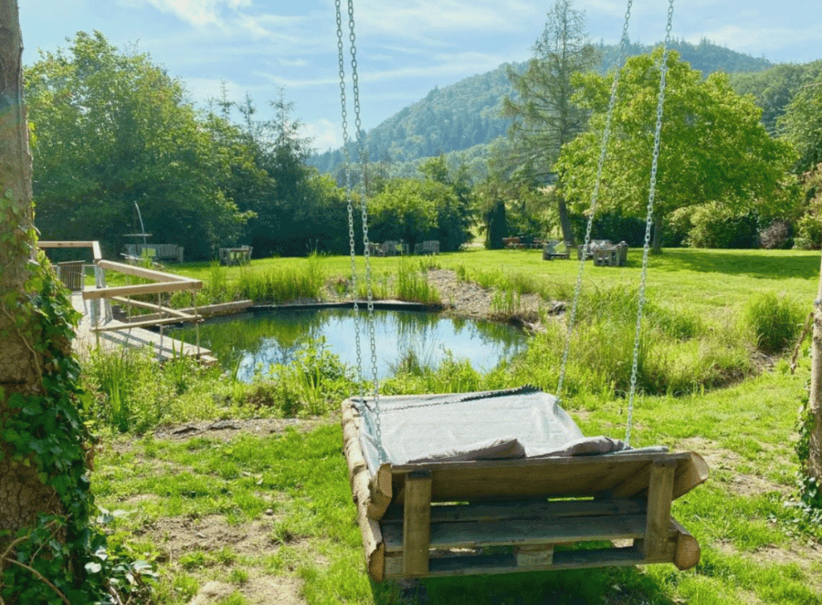
Verwöhnhotel Bastenhaus
- Spa, Sauna, Outdoor Pool
- 3 Dining Areas
- Rental Bikes
- Travel Sustainable Property
Adlerbogen Map
The blue route is an easy 2.5 mile easy route that hits so many historical highlights with minimal effort.
The pink route is the 6.4 mile medium difficulty route that goes by a ruined castle.
The yellow route is the challenging 14 miles route that also goes by Burg Hohenfels.
How to Use This Map:
Click on the icon on the top left-hand corner. You will now see an interactive list.
For more info on each, click on the map icons.
To see the map in more detail, click on the [ ] in the top right-hand corner. This will open a larger map where the details of each point can be found by clicking on the location point name in the list on the left.
You can also save the map for your own use by clicking the next to the map name. This will save the map to your Google Maps, where you can make a copy and use it for your own trip planning.
To view the saved map on your phone, open Google Maps, click “saved” on the bottom, and then “maps” on the lower right.
Adlerbogen How to Get There
The Adlerbogen is located on a forest path on the Donnersberg near Dannenfels, just 20 minutes away from Kaiserslautern. The car park at the Keltenhütte on the Donnersberg is already signposted on the federal and state roads in the area.
From there, various hiking trails lead to the Eagle Arch. Visitors can choose from different routes with varying degrees of difficulty depending on their fitness level and time constraints. It is recommended to wear sturdy shoes and bring plenty of water and snacks for the hike.
Adlerbogen Parking
Visitors can park their vehicles at the Keltenhütte on the Donnersberg, which is already signposted on the federal and state roads in the area. The car park is located at the foot of the mountain, and various hiking trails start from there leading to the Eagle Arch.
Another option is to park at the Parkplatz Dannenfels which is also signposted from the main road. From there, visitors can take a pleasant but uphill hike to the arch. It is recommended to arrive early, especially on weekends, as parking spaces can fill up quickly. Here is a Google Maps link to the various parking areas:
- Parkplatz Dannenfels – You’ll have to hike up a big hill to get there from here.
- Parkplatz Keltenhütte and Ludwigsturm – Parking at the top so you don’t have to do many hills.
Trail Guide Adlerbogen
Easy – Blue Route, 2.5 miles
Location: Dannenfels, Germany
Type of Hike: Out and Back
Distance: 2.5 miles, 4 km
Elevation: 463 ft up, 458 ft down
Duration: Approx. 1-1.5 hours
Difficulty: Easy
Start/end point: Parking Lot
Kid-friendly: yes
Stroller-friendly: a sport stroller, but not a normal one
Dog-friendly: Yes
Fees: To climb tower. Parking is free.
Something Good to Eat: Keltenhütte. They are open Saturday and Sunday from 10:30 – 18:00
🥾😓 Feeling Overwhelmed Planning a Hike? Use my custom-built online Hiking Time Calculator for Non-techie People.
Arch German
Welcome to the highest point in the Pfalz!
This hike is pretty simple and rewarding. It’s super great for a lunch date with a friend but it would be difficult to push a stroller. If you bring kids, I would certainly want to be able to carry them in some kind of pack or let them walk.
You will pass by the main highlights of this area on this short walk including the Horse fertility goddess, the TV tower, the Ludwigsturm (you can pay to walk up the stairs), the Celtic Sculpture path and the Adlerbogen.
You’ll pass by the Hirtenfels, but it’s not really that great and there’s a lot of evidence of it being a potty stop.
There are multiple places to stop and sit to eat or just take in the views.
Many people will use the parkplatz in Dannenfels and do a more aggressive uphill hike for this same area, but this gentle hike starts already on the top of the mountain making it very accessible.
Eagle Germany
Moderate – Pink Route, 6.4 miles
- Distance: 6.4 miles, 10.2 km
- Time: 3:30 to 4 hours
- Ascent: 1082 ft
- Descent: 1074 ft
Challenging – Gold Route, 14.4 miles
- Distance: 14.4 miles, 23 km
- Time: 7-8 hours
- Ascent: 2286 ft
- Descent: 2239 ft
Nearby Trails
The Pfälzer Höhenweg meanders its way through the Dannenfels area and is a major part of this hiking and walking path.
Adlerbogen History
The Eagle Arch, or Adlerbogen in German, was built in 1880 on the Moltkefelsen (Moltke Rock) to honor Field Marshal Count Helmuth von Moltke and Chancellor Otto von Bismarck.
The arch is a steel triumphal arch located on the eastern side of the Donnersberg, 545 meters above sea level, on a forest path southwest of Dannenfels.
The arch was originally a 12.50-meter-long steel structure that was stretched about 30 meters above the valley floor between two rocky peaks of the Moltkefelsen.
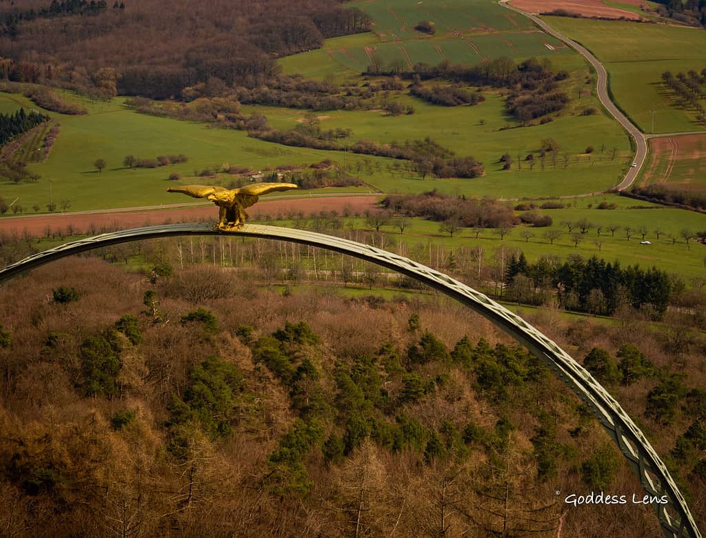
The eagle on top of the arch was shot down shortly after the end of World War II, and the statue of Bismarck was beheaded, while the statue of Moltke was stolen.
In 1981, the eagle was restored to its original design, and the arch was fully restored in 2016. Today, the Eagle Arch is a popular hiking destination and an important historical monument in the region.
Other points of interest:
The Gethsemani monastery is a kloster on the slopes of Dannenfels. Founded in 1994, it is a Trappist monastery.
The Celtic Ring wall makes for a great history lesson. It encircles the area.
The Celtic Sculpture path is also very interesting with multiple stations where you can learn about the art and artist.
A very Austin Powers looking TV tower and the historical Ludwigsturm tower are also a great spot to stop. The Ludwigsturm has a small shop to buy local products like honey and snacks and you can also pay to go up in the tower. The tower is only open in high season.
When is the Keltenhütte open?
The Keltenhütte is open Saturday and Sunday from 10:30-18:00.
What are the best things to do in Dannenfels?
The best things to do in Dannefels include:
-Hike or mountain bike the immense forest that is the highest point in the Pfalz
-Eat at Keltenhütte
-Indulge in a spa weekend at Bastenhaus
-Get in touch with history by walking the Celtic ringwall
-Get in touch with your inner artist by walking the Celtic Sculpture Path
-Get a selfie under the Adlerbogen
EXPLORE MORE MOSELLE RIVER HIDDEN GEMS
If you are curious about more German fairytale hikes, castles and wine tasting, read about more Moselle River hidden Gems:
📍 My post on wine tasting and hiking in Urzig
🍷 The Best Things to do in Beilstein on the Moselle
🏰 And… the best things to do in Cochem Germany

Author profile: Morgan Fielder is a Doctor of Physical Therapy and passionate hiker who believes in exploring the world on foot with good food. Follow her journey as she shares science-based hiking tips and advocates for sustainable tourism.