
Western Germany is perfect for a spooky Halloween hike!

The scariest haunted trails and castles Germany has to offer.
As an expat in Europe, sometimes I really miss Halloween. The costumes, candy and crazy home decorations.
While Halloween is catching on, like most European things it’s less commercial and more natural and rooted in history.
This article helps you to explore the outdoor Halloween and natural spooky side of Germany.
Haunted hikes, spooky trails and the most gorgeous Fall colors make Halloween the perfect time to enjoy the German Outdoors.
This hiking guide is created so you don’t need any special apps. Each family friendly hike comes with a clickable free google TRAIL Guide so you know the best places to eat, things to see and won’t get lost along the trail.
Unless you want to.

Top 5 Halloween Hikes in Germany
1. Ultimate Halloween Hike: Frankenstein’s Castle
2. Easiest Halloween Hike: Devil’s Table
3. Best Adventure Halloween Hike: Dragon’s Stone
4. Best Witchy Halloween Hike: Hexenklamm
5. Most Stroller Friendly & Historical Halloween Hike: Berwartstein Castle
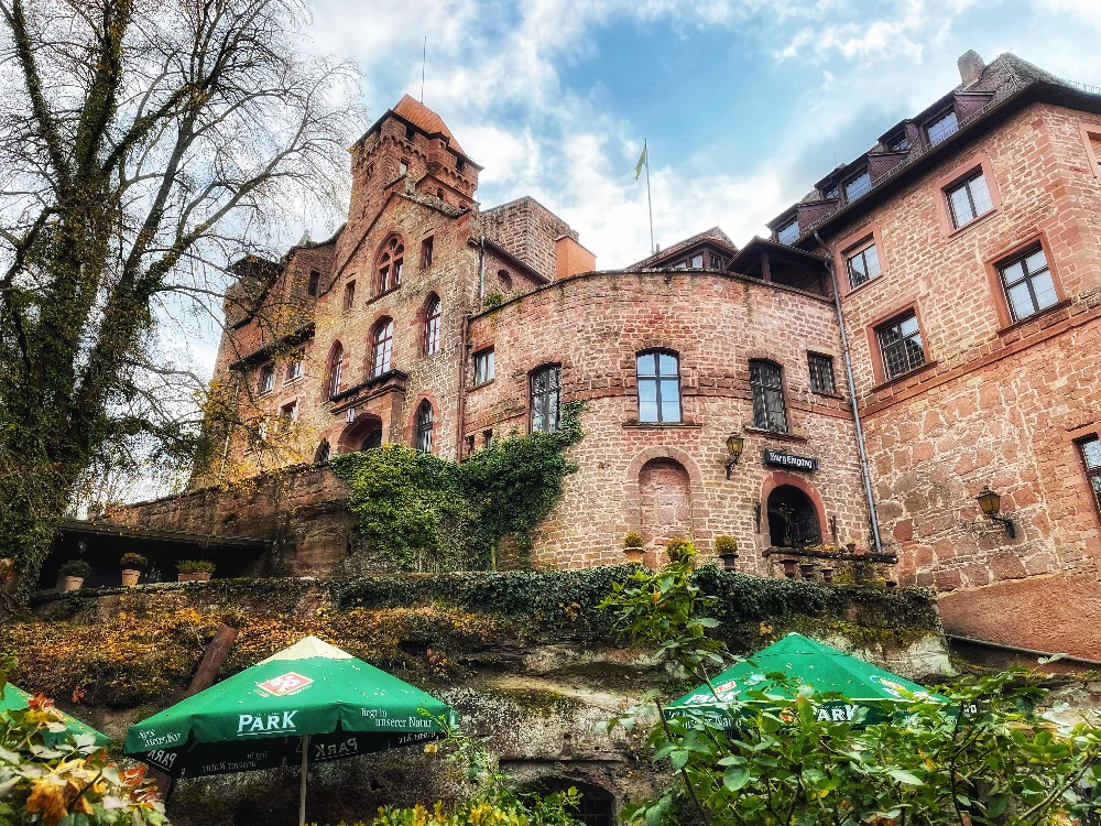
Ultimate Halloween Hike
Frankenstein’s Castle

The content of this website may contain affiliate links and we may be compensated (at no cost to you!) Thank you for your support!
Mary Shelley took a road trip nearby when pro “alchemist” Johann Dippel worked on soul transference & created the “elixir of life” out of animal fluids here at Burg Frankenstein.
Trail Name: Ultimate Easy and Spooky Halloween Hike at Frankenstein Castle
This hike is for you if you an easy mostly stroller-friendly path through dark woods, clowns peeping at you from the belltower, and fairycore forest surroundings.

Take an opportunity to calm your fears of the undead with the long Barfusspfad (Shiatsu Foot massage path) and healing herb garden to smell and touch medicinal plants.

Location: Darmstadt Germany: 1:15 from K-Town
Type of Hike: Loop
Distance: 1.4 miles
Elevation: 150 ft up, 175 ft down
Duration: Approx. 30-60 min
Difficulty: Easy
Start/end point: Parking lot: https://goo.gl/maps/vPRryMwAFf5xwE9v7
Kid-friendly: yes
🥾😓 Feeling Overwhelmed Planning a Hike? Use my custom-built online Hiking Time Calculator for Non-techie People.
Stroller-friendly: Yes – But Spooky Woods & Herb Garden You’ll want to park it and walk
Dog-friendly: Yes

Fees: none to hike, but Halloween “show” has tickets
Camino de Santiago: no
Halloween Tickets and Eat Here: https://www.frankenstein-halloween.de/tickets/

UNTIL NOV 6 – THERE’S A HALLOWEEN SHOW AND OTHER TIMES OF YEAR THERE’S POETRY SLAMS AND CONCERTS. TALK ABOUT SPOOKY AMBIENCE.
Podcast: Listen to the History Here at Atlas Obscura. https://www.atlasobscura.com/…/podcast-the-real…
Stay: If you’re driving from Bavaria or France and don’t want to pay for a hotel, my daughter and I have had great success with turning the back of our SUV into a “camper”. It’s legal to sleep in your car in Germany as long as you are in a legal parking spot.
Google Map: Ultimate Easy and Spooky Halloween Hike at Frankenstein Castle
How to use this map: Use your computer mouse or fingers to zoom in and out. Click on the icons to get more information. Click the arrow on the top left corner for the written index. Click the star next to the title of the map to add this map to your google maps account. To view the saved map on your smartphone or PC, open google maps, click the menu button, and go to “your places”/ “maps.”
Komoot App with GPS Tracking: Komoot allows one free region so you don’t have to subscribe to use this. It’s an easy to use app for hiking.
Use my “tour” that I personally created to have this particular hike on your phone. Even without a good mobile signal, you can use your phone’s GPS and follow the red dot.
https://www.komoot.com/tour/539354533
Easiest Halloween Hike
Devil’s Table – Teufelstisch

This hike is for you if you’re into mushrooms and one of German’s most incredible rock formations called Teufelstisch. Meaning the Devil’s Table, it almost looks like an upside-down mushroom.
It’s an easy walk from the parking lot to get to this famous and impressive rock formation that seems impossible with gravity.
Trail Name: Devil’s Table Halloween Family Hike
Location: Outside Pirmasens, Germany–30 min from Landstuhl
Type of Hike: 2 Loops
Distance: 1.5 miles
Elevation: 350 ft up, 300 ft down
Duration: Approx. 30-60 min
Difficulty: Easy
Start/end point: Parkplatz Erlebnispark https://goo.gl/maps/f9kttCBcKQuajqj
Kid-friendly: yes
Stroller-friendly: no
Dog-friendly: yes
Fees: yes, parking
Camino de Santiago: no
Eat Here: Spooky Bier Garten Brauhaus Ehrstein.
Michelin Style: Die Brasserie for a high-end experience. Reserve a table at this 1 star Michelin restaurant in the forest.
This hike in the heart of Felsland (Rock Land) in the Palatinate forest astounds with the coolest rock formation called the Devil’s Table, a wicked cool playground, and a mushroom extravaganza loop called Handschuhe. Meaning “glove” in German.
Maybe the glove of Satan fell under his table?

Let the kids walk or carry the babies on your back. This hiking pack helps you carry even the most robust babies and toddlers (like my cute tank of a grand nephew) with less strain and neck or backaches.
Devil’s Table Halloween Family Hike on Google:
How to use this map: Use your computer mouse or fingers to zoom in and out. Click on the icons to get more information. Click the arrow on the top left corner for the written index. Click the star next to the title of the map to add this map to your google maps account. To view the saved map on your smartphone or PC, open google maps, click the menu button, and go to “your places”/ “maps.”
Komoot App with GPS Tracking:
https://www.komoot.com/tour/537857332
Best Adventure Halloween Hike
Drachenfels: Dragon Stone

Trail Name: Dragon’s Stone Adventure Halloween Hike – Drachenfels – Schlüsellfels Loop
This hike is for you if you want incredible views scrambling up the ruined Dragon’s Stone Castle and a little spine-tingling balancing & jumping atop the Key Rock ridge – – the highest sandstone face in the Wasgau forest perched atop a seriously steep conical hill.

Location: Outside Busenberg, Germany–60 min from Landstuhl
Type of Hike: Loop
Distance: 3.6 miles
Elevation: 675 ft up, 700 ft down
Duration: Approx. 1.5 – 2 hours
Difficulty: Easy-Moderate
Start/end point: Parking lot free: https://goo.gl/maps/XhFC8eqAv7csZz1J6
Kid-friendly: yes: ages 5+
Stroller-friendly: No
Dog-friendly: Yes
Fees: none
Camino de Santiago: yes, a brief touch
Eat Here: http://www.pwv-busenberg.de/ Drachenfels Hütte Wed/Sat/Sun 11-18:00
THE HIKE IS GREAT FOR HALLOWEEN WITH THE DRAGON’S ROCK MYTHOLOGY AND FOR THOSE SEEKING A LITTLE ACTION.
If you’re into mountain adventures and want to plan a hiking trip to the Dolomites next summer, book your huts now. They fill up fast. Here’s a free packing list for hut to hut hiking in the Dolomites, just in time for Christmas.
Trails lie on the very top of the Schlüsselfels – you’ve got to jump from one part to the other and it’s a sheer drop on either side. (I took a look and decided not to jump carrying my Goldendoodle Ruby.)

Beyond the incredible sandstone rock formations everywhere and amazing ruined and complete castles, the Wasgau forest is a leep peepers heaven.
It’s filled with twisty pine trees with evergreen only at the top and like Christmas garland the leafy trees wrap around the trunks in blaze orange, crimson and bright yellows.
The hills rise up like traffic cones, so while steep it doesn’t take very long to get to the top for incredible views.
Dragon’s Stone Adventure Halloween Hike – DrachenFels – Schlüsellfels Loop on Google
How to use this map: Use your computer mouse or fingers to zoom in and out. Click on the icons to get more information. Click the arrow on the top left corner for the written index. Click the star next to the title of the map to add this map to your google maps account. To view the saved map on your smartphone or PC, open google maps, click the menu button, and go to “your places”/ “maps.”
Komoot App with GPS Tracking:
https://www.komoot.com/tour/538014084?ref=wtd
Best Witchy Halloween Hike
Hexenklamm

This hike is for you if you want a little spooky-ness and fun with an easy hike for kids, toddlers or adults only. Lots of drama, mushrooms, and foliage on a short but scenic hike.
Trail Name: Hexenklamm Halloween Easy Hike

Location: Outside Pirmasens, Germany–30 min from Landstuhl
Type of Hike: Loop (steps) or Out and Back (stroller friendly)
Distance: 2.2 miles
Elevation: 275 ft up, 275 ft down
Duration: Approx. 1 hour
Difficulty: Easy
Start/end point: Parking lot free https://goo.gl/maps/GQedDBCWA9AXbqrn8
Kid-friendly: yes
Stroller-friendly: Yes, but…only 1/2 way.
If you want to have more fun, ditch the stroller and go into ravine, it’s worth it and short enough for toddlers to walk or be carried. If you don’t want to carry or kids want to walk, you can stay to the east side of ravine and stroller the whole way but views are a bit limited.
Dog-friendly: Yes
Fees: none
Camino de Santiago: no

Hexenklamm Halloween Easy Hike for Families Trail Guide on Google:
How to use this map: Use your computer mouse or fingers to zoom in and out. Click on the icons to get more information. Click the arrow on the top left corner for the written index. Click the star next to the title of the map to add this map to your google maps account. To view the saved map on your smartphone or PC, open google maps, click the menu button, and go to “your places”/ “maps.”
Komoot: https://www.komoot.com/tour/537772186?ref=wtd

Most Stroller Friendly and Historical Halloween Hike
Berwartstein Castle

This hike is for you if you want a stroller friendly, super historical and fantastic Alsatian wine and food. The operational castle has tours year-round to add to your hike and was infamous for it’s owners’ misdeeds. Known as the “Robber Barron.”
Trail Name: Berwartstein Stroller Friendly and Historical Halloween Hike
Location: Erlenbach bei Dahn, Germany — 60 min from Landstuhl
Type of Hike: 2 Loops
Distance: 2.5 miles
Elevation: 125 ft up, 175 ft down
Duration: Approx. 60-75 min
Difficulty: Easy
Start/end point: Parkplatz https://goo.gl/maps/FfKxsg78F21sLAKi9
Kid-friendly: yes
Stroller-friendly: yes
Dog-friendly: yes
Fees: no
Camino de Santiago: Yes – Long Stretches on Camino
Eat Here: At the Entrance to the Castle lies a fabulous flammkuchen and wine, beer garten to taste Alsatian delights.
Castle Tour: Check times, open Year round.
This mostly flat hike has something for everyone, food, lake stroll, castle tours, & delicious Reisling.
If you want to check out another cool castle hike check out this one with the castle ruins in Landstuhl just above the town center.
Starting at the Burg Berwartstein parking lot, first loop around castle then loop around the Seehofweier/Portsbach lake, it’s very flat and suitable for all stroller types.
This castle is operational and spooky as anything. It was owned by a knight in the middle ages so bloodthirsty, he flooded the town of Wissembourg murdering people and killing business in retaliation to the monks who challenged him.
Beware Hans von Trotha!
Berwartstein Stroller Friendly and Historical Halloween Hike on Google:
How to use this map: Use your computer mouse or fingers to zoom in and out. Click on the icons to get more information. Click the arrow on the top left corner for the written index. Click the star next to the title of the map to add this map to your google maps account. To view the saved map on your smartphone or PC, open google maps, click the menu button, and go to “your places”/ “maps.”
Komoot App with GPS Tracking:
https://www.komoot.com/tour/538164070?ref=wtd
I hope you enjoy Germany’s great Halloween Hikes as much as we do. Until next time!
Please share with a friend you think would enjoy it!
with , Crave the Planet
Author profile: Morgan Fielder is a passionate hiker and writer, physical therapist, and European Cornhole Commissioner. She is living near Ramstein Air Force Base in Germany and featured giving science-based hiking tips and advice.
When not out exploring the mountains or sea, she’s writing articles and gear reviews to empower Outdoor Journeys that include family and good food. She is actively involved in the community and advocating for connection and sustainability with her community projects at Cornhole Europa and Sustainable Investors Group.