
Nestled in the picturesque Bavarian landscape, the Hoher Kranzberg hike near Mittenwald is perfect for nature lovers and hikers that want incredible panorama views without having to summit rocky mountains.
The Bavarian Alps are overhyped.
That’s what I thought after 4 trips feeling like a cow in a herd on popular hiking trails.
Then after dozens of hours of research and a Juneteenth hiking trip near Mittenwald – it may be my favorite place for turquoise lakes and fairly easy hikes with dramatic views.
We encountered about 20 total people in 4 hours on this trail. We did the long loop, but shorter routes are easy and I’ve included them on the map if you’ve got kids or dads in your group that get cranky.
TL;DR: This “soft hike” is perfect for a half day summer (or even winter hike) for those that want maximal scenery with minimal effort. It’s not high elevation and there are options for chairlifts to take you to the top, lakes to swim and delicious mountain huts serving cold beer, wine and hot food.
The panoramic mountain, standing at 1,391 meters, offers a stunning 360-degree view of the surroundings that will captivate your senses. Thanks to its year-round accessibility, you can enjoy the beauty of this area in different seasons.
| Want More Help With a Certified Mountain Guide?
Enjoy some of Austria’s most beautiful scenery on this Private Full-Day Hike through the nearby Karwendel. Hike safely and at a speed appropriate to your level of experience. A stop at the Pfeishutte will have cold beer and food!
Hoher Kranzberg Mittenwald Hike Overview
Where to Stay: Mittenwald
Distance: 7.4 mi, 11.9 km
Elevation: 1754 ft, 530 m up/down
Difficulty: Moderate. About 2.5-3.5 hours
⛰ More Adventure? Book a Hut to Hut Hiking Tour
You will encounter two lovely lakes and a variety of flora and fauna, making it an ideal spot for birding, hiking, running, and photography.
I love that there is a barefoot park (a place to do free reflexology on your feet with a path of variable textures to walk barefoot over) and a mountain tricycle. It’s fun for every generation.
So whether you want a challenging half day hike or an outing to a somewhat secluded alpine lake, there’s something for everyone.
Morgan’s Hoher Kranzberg Youtube
Mittenwald Hiking Trail Route and Map
How to use this map: Use your computer mouse or fingers to zoom in and out. Click on the icons to get more information. Click the arrow on the top left corner for the written index. Click the star next to the title of the map to add this map to your google maps account. To view the saved map on your smartphone or PC, open google maps, click the menu button, and go to “your places”/ “maps.”
Your Choices
- Use the chair lift taking you most of the way up. From there, its .75 mi (1.2km) to the top on a dirt road and steep with 500 ft (150m) of up/down. Return down .75 mi to gondola.
✅ Best for newbies. Do the barefoot path, or ride mountain tricycle down. - The middle route also has 500 ft (150m) of up/down but is longer and less steep. It will get you to 2 alpine lakes and the mountain huts and is 5.4 mi and takes 2-2:30 hours. You don’t get to the outlook, but the views are incredible and the paths are easy.
🌈 ⭐️ Probably the best route for families. - The 7.4 mile(11.9km) loop trail for lakes and outlook is considered moderately challenging, with 1500 ft up/down, taking an average of 3.5 to 4 hours to complete.
🥾Probably best for hikers. - No car? Train loop has lakes and outlook and is 8.7 mi (14km) has 1735 feet (528 m) up/down and takes 4.5 to 5 hours to complete.
- Here’s my free GPS Komoot of the different hikes so you can choose.
Getting to and Around Kranzberg
Transportation to Mittenwald By Train
To get to Mittenwald, your most convenient option is taking a train from Garmisch-Partenkirchen. The train journey is approximately 20 minutes, and you’ll enjoy scenic views while traveling through the beautiful Bavarian countryside. You can check train schedules and book your ticket on the Deutsche Bahn website.
Once you arrive at the Mittenwald train station, it’s only a short walk to the starting point of your hike. Mittenwald is a super charming town, so take your time strolling through its picturesque streets before you start your hike.
Become a European Adventure Travel Insider in Just 5 minutes
✨Unlock Europe’s best-kept secrets with our free bi-weekly newsletter.
By Car
Click here for the GPS of the parking lot at the Kranzberg Chair lift Valley Station. You’ll need to pay for parking by using the posted parking App or Euro coins.
Kranzberg Chair Lift
While preparing for your hike, you might consider taking the Kranzberg Chair Lift to easily reach the viewpoint. This option is particularly suited for those who want to shorten the ascent or save some energy for the hike itself. The chair lift operates year-round, with schedules subject to change depending on the season and weather.
Here is a quick overview of the Kranzberg Chair Lift:
- Starting Point: Talstation Kranzbergbahn, Kranzbergstraße 24, 82481 Mittenwald
- Operating Hours: Vary depending on the season; check the official website for updated information
- Ticket Prices: Adults (One-way: €8.50, Round-trip: €12.50), Children (One-way: €4.50, Round-trip: €7.50)
By taking the Kranzberg Chair Lift, you’ll be able to enjoy panoramic views of the surrounding mountains while comfortably seated.
It would be fantastic to bring the kids and do the mountain tricycle here also. You basically rent the trike and go up the chairlift with it, and fly down a special trail.
Hoher Kranzberg Trail Description: Loop
Trailhead – Lautersee: 30 min
Starting Point: Talstation Kranzbergbahn, Kranzbergstraße 24, 82481 Mittenwald
After you park the car start walking south toward Lautersee. The yellow signs are very easy to follow. It will being with paved roads with some short steep hills. We heard the sound of German polka from the town of Mittenwald down below on your left. We lucked out as Juneteenth weekend is also the violin making festival in Mittenwald and the Zugsptize ultra marathon event. It was very jovial.
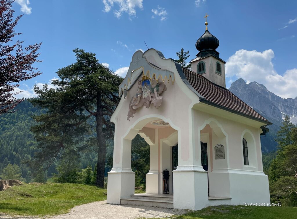
Once you turn into the forest, ensure you turn around and look backward as the Karewendel peaks are massive and beautiful. Notice the small “kappelle” or chapel, before you reach the Lautersee Almhütte.
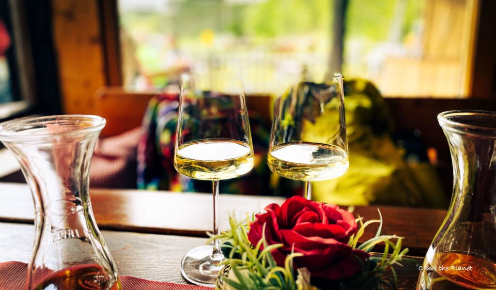
We loved the dry white wine here and watching the kids jump into the crystal clear lake from the diving board. They offer a full menu.
The swim area has snacks also and costs 2-4 euros to enter depending on age.
The trail up to here is stroller friendly.
Lautersee – Ferchensee: 1:10
I think next time we’ll wait to eat at Ferchensee because it’s even more beautiful than Lautersee. I also won’t forget my swimsuit next time as the water is fantastic and the mountains perfectly frame the lake.
Also you can push a stroller here and there looked to be a bus connection from the valley floor. No private cars however.
Ferchensee – Hoher Kranzberg: 2:40
This is the bulk of the hike, take path 813 from the lake up into the forest. The trails get more challenging here and there are plenty of places to sit with benches next to the trail. It’s a forest fairy land.
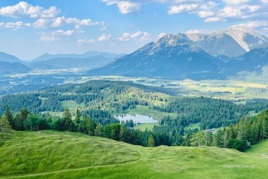
Once you reach the summit, there are 360 degree views that make you think you are Maria in the Sound of Music. My favorite thing was to spot Zugspitze and Wildensee Lake from a curvy wooden chair.
Here you can take the gondola or a mountain tricycle down if you aren’t passed their opening hours.
H. Kranz – Valley Station: 3:00
It’s a beautiful, albeit steep trail down to where you parked the car.
Natural Wonders and Scenic Views
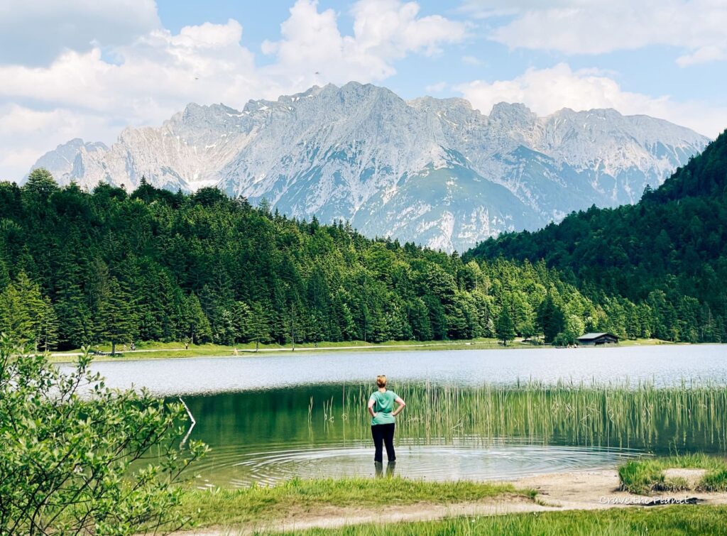
Lautersee and Ferchensee Lakes
While hiking this trail, you’ll come across two beautiful alpine lakes, Lautersee and Ferchensee. This loop trail starts at the base station of the Kranzberg chair lift and leads you to these stunning lakes.
Lautersee is a picturesque lake that offers tranquility amidst nature, perfect for a leisurely stop. On the other hand, Ferchensee lake has crystal-clear water and is encircled by lush greenery and towering mountains. Both of these lakes provide excellent opportunities for relaxation, swimming, or even a lakeside picnic.
Mountain Peaks and Valleys
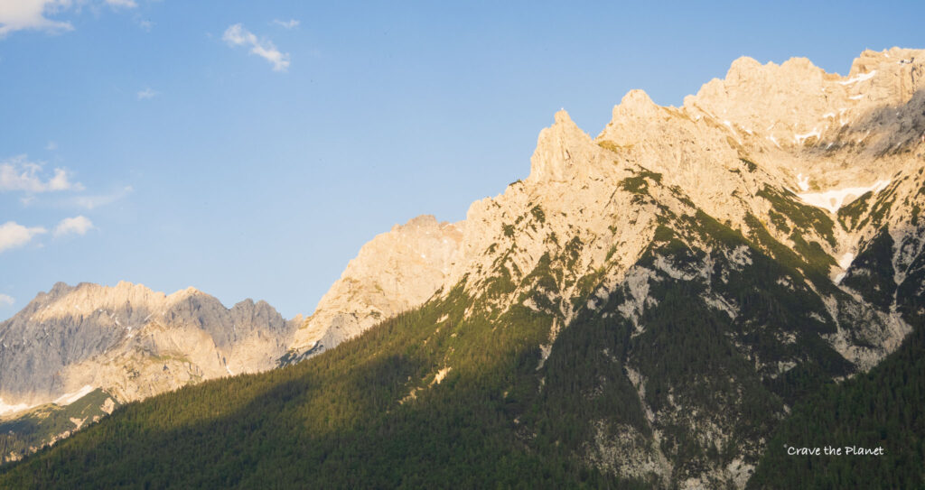
As you continue your hike, you’ll be rewarded with breathtaking views of the Karwendel Westkamm chain and Wetterstein peaks from the peak overlook. The 1,391-meter high summit promises an all-around, 360° view of the surrounding mountain ranges, making your hike worthwhile.
Hiking Seasons and Conditions
Warm Season Hikes
The warm season hikes provide dramatic views of the Karwendel Westkamm chain and Wetterstein peaks. You can even spot Zugspitze and Alpspitze.
During the warm season, good hiking shoes, sun protection, and hydration are crucial to ensure a safe and enjoyable experience. Trail conditions are usually stable, but it’s always a good idea to check the weather forecast prior to your hike.
Winter Hikes and Snowshoeing
As it’s not high elevation, it offers winter hiking and snowshoeing opportunities as well. Thanks to its accessibility all-year-round, you can explore the beautiful snowy landscapes and experience the tranquil beauty of the area during the colder months. Winter hikes can be a bit more challenging due to snow and ice, so appropriate footwear and clothing are essential. Trekking poles and snowshoes can offer extra stability and support when traversing snowy or icy terrain.
In winter, it’s wise to start your hike early as daylight hours are limited. Also, make sure to check the weather forecast and trail conditions before heading out, as sudden changes can happen in the mountains.
During both warm and cold seasons, consider taking the train to your starting point to minimize your environmental impact and make your journey more enjoyable.
Rest Stops and Accommodations
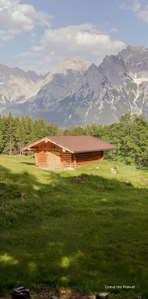
During your Hoher Kranzberg Mittenwald hike, you’ll encounter various mountain huts and accommodations to relax, grab a bite, and even spend the night if you wish. Or make a potty stop!
Mountain Hiking Huts
- Kranzberg Sesselift: The hike starts at the Kranzberg Sesselift (Chair lift) in Mittenwald. This lift can take you directly to the Hoher Kranzberg if you want to skip the ascent, or you can use it as a starting point to hike up the mountain.
- Lautersee Lake: Another scenic spot on your journey is Lautersee Lake, where you can take a break, enjoy some food at the Lautersee Alm Hütte, and admire the beautiful surroundings.
- Ferchensee Lake: As you continue your hike, you’ll come across the beautiful Ferchensee Lake. This spot offers picturesque views, and you can find food and drinks at Gasthaus Ferchensee.
Remember that the Hoher Kranzberg hike offers a 360° panoramic view from its summit, showcasing the impressive peaks of the Karwendel Westkamm chain and Wetterstein Mountain range. Don’t forget to bring a camera to capture the stunning views!
Final Verdict: It’s a Soft Hiker’s Paradise
With its unique panoramic views and serene atmosphere, the Höher Kranzberg hike promises an unforgettable experience and is family and winter friendly.
This hike is definitely worth it if you are anywhere near Innsbruck Austria, Munich, or the Bavarian Alps.
It’s not especially rugged, but you get incredible Alpine vibes.
Planning your trip?
- 🏨 Book your perfect stay on Booking.com
- 🎢 Make your trip more exciting with GetYourGuide
- 🚗 Hire a car with Discover Cars
- ✈️ Find cheap flight tickets with WayAway
- 📲 Buy eSIMs with Airalo
Mittenwald Hiking Frequently Asked Questions
How long does it take to hike to Hoher Kranzberg from Mittenwald?
The hike from Mittenwald to the summit of Hoher Kranzberg typically takes about 1 to 1 hour and 20 minutes. This duration may vary depending on your fitness level and the route you choose to take. Keep in mind that allowing time to enjoy the views and take breaks is always a good idea.
What is the difficulty level of this hike?
The Hoher Kranzberg hike is considered to be of moderate difficulty. The trail is mostly well-maintained, but there may be some steep sections and uneven terrain. It is recommended for hikers with some experience, but it is also manageable for those who are in relatively good physical shape.
Are there any guided tours available for the High Viewpoint?
There’s ample signs and a guide isn’t necessary. Guided tours for the Hoher Kranzberg hike may be available, but they are not as common as tours for more popular destinations. It’s always a good idea to check the local Mittenwald tourist office or adventure tour companies for any available guided tours during your visit.
What is the best time of year to hike Hoher Kranzberg in Mittenwald?
The best time of year to hike Hoher Kranzberg in Mittenwald is from late spring to early autumn, as the weather is generally more pleasant, and the trails are more accessible. Hiking in the winter months is possible but may require additional equipment like trekking poles and microspikes and preparation due to snow and cold conditions.
Are there any facilities or accommodations nearby?
Yes! There 2 main facilities available near Hoher Kranzberg, such as the 2 mountain huts offering food and refreshments. However, the town of Mittenwald (20 min walk) has a wider range of accommodations, including hotels, guesthouses, and holiday apartments, making it a great base for exploring the area and hiking Hoher Kranzberg.
Can I bring my dog on the Hoher Kranzberg hike in Mittenwald?
Yes, you can bring your dog. Keep in mind, though, to always observe local regulations and etiquette regarding leash rules and cleaning up after your pet. It’s also essential to ensure your dog is well-prepared for the hike, including having enough water.
More Northern Alps Travel Blogs
We hope this Hoher Kranzberg hike guide has given you the proper information to plan your visit to this hidden gem in Germany!
Author profile: Morgan Fielder is a Doctor of Physical Therapy and passionate hiker who believes in exploring the world on foot with good food. Follow her journey as she shares science-based hiking tips and advocates for sustainable tourism.